 At the heart of the ArcticHubs project are a number of tools that are seeking to access a broad range of views and voices, through which to shape solutions when addressing the urgent challenges around land-use conflict in the Arctic. To avoid an overload of one-way quizzing from researchers – probing for an understanding through which to frame recommendations –
ArcticHubs has instead moved towards a co-design approach.
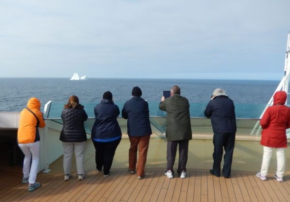
Placing an emphasis on gathering and sharing knowledge of the increasingly complex local land-use situations, ArcticHubs project is hoping it will become clearer to observe where and why competition and tensions may arise. In particular the project is moving to target substantive local participation and to provide channels or methods for continuous communication and dialogue with stakeholder groups. One form of this approach is known as ‘Public participatory GIS’ or PPGIS. More specifically, the hubs of the project are applying a version of PPGIS called Maptionnaire, through its partnership with the creators of the model the Helsinki based company Mapita.
What is Maptionnaire?
For some time now there has been an increasing demand for planners, policy makers and other interested parties, to connect more directly with the public and build up real input from local residents and communities. The Maptionnaire tool emerged from this situation through the use of individual questionnaires, maps and images on a flexible community engagement platform. With this method it is able to compile large-scale sets of information directly drawn from local audiences. Building on the increasingly adaptive technologies of GIS (Geographical Information System mapping), Maptionnaire allows for the immediate gathering then rapid analysis of significant sets of information, including opinions and subjective data straight from local respondents. In so doing it aims to support participative efforts, that provide feedback, improved interactions between specialists and local citizens, and a clarity of understanding across individual or group perspectives.
Bringing Maptionnaire to the ArcticHubs
Having been utilised across a range of projects and settings for more than a decade, this adaptable tool is now being tested by ArcticHubs in the more sophisticated backdrop of its multi-sectoral hubs. Initially the project has chosen to trial the approach in three pilot hub locations in the Arctic:
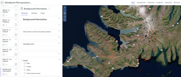
- The Westfjords of Iceland
- Magma UNESCO global geopark in southern Norway
- The Inari region in the far north of Finland
In these separate areas, the research partner teams are examining how local audiences can access Maptionnaire and respond to the pressing research questions that apply in each individual hub locality. The main topic of the initial questionnaires was land-use changes caused by tourism and fishing.
All three pilot questionnaires contained common questions along with questions that were modified to fit better to the local conditions.
The aim was to reveal how the participants in the pilot research areas have observed and experienced land-use changes.
Respondents could then take the opportunity to contribute towards:
- A series of mapped layers
- Indications of areas within the hubs where competing interests arise
- Or just raising taking note of the different stakeholders’ opinions
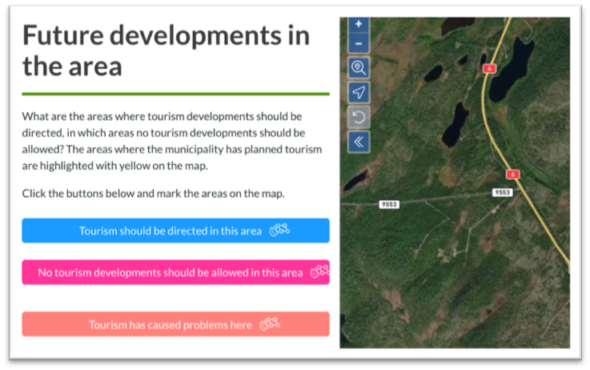
Pilot questionnaires contained mapping questions and each questionnaire has been created in the editor by adding the question elements one by one. In the example below, respondents were asked to mark on the map e.g. areas where tourism should be developed and areas that should not be developed for tourism.
Recognising that Maptionnaire is not a ‘one size fits all’ solution, means further reflection and exchange of analysis will need to take place as the use of the tool extends from the beta phase to hub sites across the entire project. During these later phases of development, greater opportunities to more fully co-create questionnaires with local citizens will hopefully emerge.
This will be important, as early feedback during this beta phase of Maptionnaire highlights indicates that not all respondents are comfortable with sketching out responses individually on digital maps. Furthermore, it is not a given that all local citizens are even motivated to respond to a questionnaire at all. For example, one hub locality is finding that younger generations seem less enthusiastic to file their views via formal looking questionnaires. The different hub localities and research teams across the project will therefore need to consider closely how different local groupings can be encouraged to contribute more fully through the various research tools.
With 3 more years of the ArcticHubs project to run, the application of the PPGIS Maptionnaire tool to the ArcticHubs is only just emerging!
However, initial questions are being framed so that they may be repeated in the later phases of the project. In this manner comparisons with other data sets may be made. Furthermore, the data drawn from hub-based respondents to Maptionnaire will be complemented and utilised alongside other research tools applied in subsequent work packages, ensuring a holistic and comparative set of results and solutions are derived from the project a whole.